Sample Collection Events
Sample Collection Events
Volunteers can collect samples for the Chesapeake Water Watch any day of the year, but sometimes we host special collection events. During these events, we highlight days where data makes an extra impact. On these days we often offer special sample drop-off hours, open additional testing sites, and test all the samples for you (even at self-testing locations!).
To more about upcoming events and how to take samples, keep scrolling!
Upcoming Collection Events
HydroColor Collection Day: April 9th, 2025
Grab your gray card and head out to your favorite dock! HydroColor Collection days are great ways to collect data for the Chesapeake Water Watch while there is a satellite overhead! Don't forget to upload your observations to FieldScope so the whole CWW community can see your findings.
You'll need a:
- CWW Datasheet
- An 18% Photography Gray Card
- A clipboard (optional, but recommended)
- A smart phone with the HydroColor App downloaded
To learn how to take a HydroColor Sample, you can watch this training video.
Satellites and Samples: April 14th, 2025, August 12th, 2025 (Click on dates to learn more)
There will be two high-resolution satellites, Landsat-9 and Sentinel-2a, gracing the skies above the Chesapeake Bay. We can use your water samples to improve the water quality monitoring algorithms for not one but two satellites.
Getting involved is as easy as 1,2,3! :
- Collect a water and/or HydroColor sample from the Bay or from any tidal river that flows into the Bay
- Fill out a quick data sheet
- Drop off your sample at a nearby collection hub
Your small act can make a big impact in monitoring our coastal ecosystems. Don't miss out on the fun!
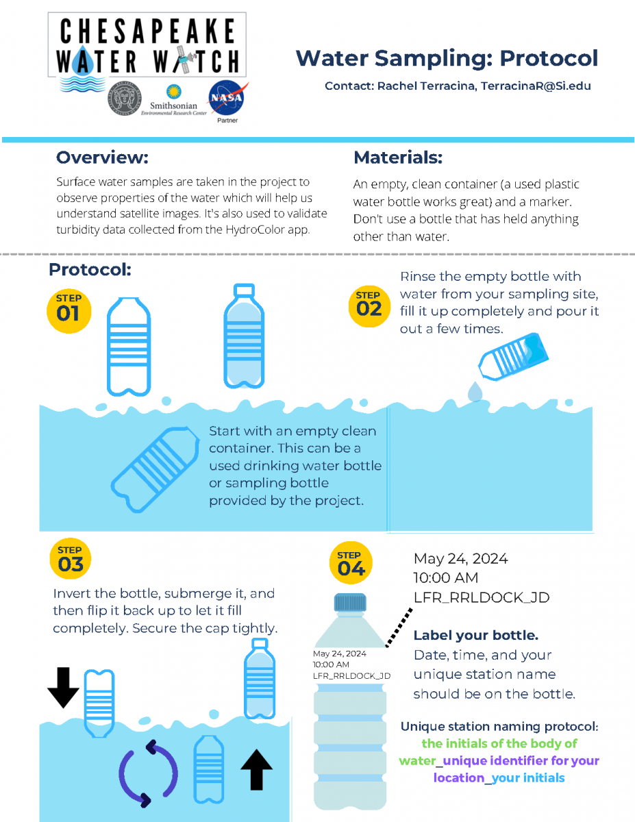
What You'll Need for Water Collection Events
An empty plastic water bottle
A smartphone/device to record GPS coordinates
CWW Datasheet (or piece of paper to record data)
A rubber band (or something similar) to attach datasheet to sample bottle
Common Collection Hubs
*For Collection Events: check the "Events Page" for the most accurate information about drop-off locations *
Please note: During collection events, most "self-testing" sites become drop-off locations
Smithsonian Environmental Research Center
Contact: Ray Terracina (TerracinaR@si.edu)
647 Contees Wharf Road,
Edgewater, MD 21037
Drop-off window: 8AM - 3PM
Press red button above cooler to notify of drop-off.
Anne Arundel Community College
Contact: Tammy Domanski (tldomanski@aacc.edu)
101 College Parkway,
Arnold, MD 21012
(443) 994-9236
Drop-off window: 9AM - 3PM
Scan QR code to notify drop-off.
Marshy Point Nature Center
*SELF TESTING LOCATION*
Contact: Ray Terracina (TerracinaR@si.edu)
7130 Marshy Point Rd,
Middle River, MD 21220
Testing window: 9AM - 4:30PM
Enter the classroom on the left, walk to the back corner with cabinets to find the CWW machines and protocol binder. Follow step by step instructions to test your sample. Send a photo of completed data sheet to Ray at TerracinaR@si.edu or upload results directly into Fieldscope.
The Ryan Resilience Lab
*SELF TESTING LOCATION*
Contact: Ray Terracina (TerracinaR@si.edu)
4610 Colley Ave.
Norfolk, VA, 23508
Drop-off window: 9AM - 4PM
Head in through the front door and let the person at the front desk know you are testing or dropping off a Chesapeake Water Watch Sample. If dropping off for a collection event, scan the QR code to notify us you dropped off a sample.
How To
Click on the image to view the PDF version
CWW Virtual Training: Collecting a Water Sample
For drop-off locations that are not at SERC, you may stop the video at 1:44.
Get GPS Coordinates on Google Maps and Apple Maps
This is very important! Accurate GPS points are required for successful data analysis. No GPS location = We can’t use the data!
Google Maps
Android
- On your Android phone or tablet, open the Google Maps app
.
- Touch and hold an area of the map that isn’t labeled to drop a red pin.
- In the search box, you can find the coordinates.
iPhone or iPad
- On your iPhone or iPad, open the Google Maps app
- Touch and hold an area of the map that isn’t labeled to drop a red pin.
- At the bottom, tap Dropped pin to find the coordinates.
Apple Maps
Get GPS Coordinates in Maps on iPhone and iPad
Open Maps on your iPhone or iPad and then follow these steps to get your current location’s GPS coordinates.
- Tap the current location button on the top right.
- When the blue circle for your spot appears on the map, tap it.
- Swipe up from the bottom to view full details for your location and you’ll see the Latitude and Longitude.
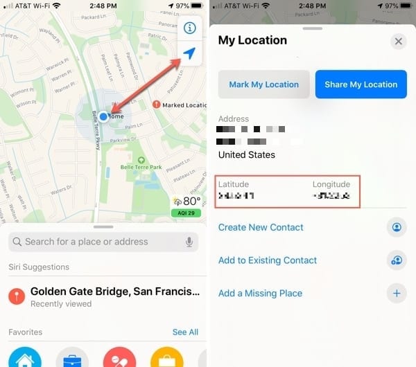
Credit: AppleToolBox
Not sure where to go?
Collection Tips
- Your safety is our #1 priority. If weather does not permit for collection, that’s okay! We will have more events and ways to get involved in the future.
- Be sure to write clearly on your data sheet! We need to be able to match up the water sample to the data on your datasheet. Without both, we won’t be able to use your sample!
- Try to take a water sample as far from the shore as possible. If it’s too close to shore, wave action may contaminate the sample and not give us an accurate representation of the overall body of water.
- Transport your water sample in a cooler or thick bag. Some of the measurements we get from water samples can be affected by heat and light.